Development of Land Cover and Carbon Storage in Plawangan Hill of Gunung Merapi National Park, Yogyakarta, Using Landsat Data Series 2009, 2013, 2017, and 2023

Article Sidebar
-
forest canopy density, model, climate changes, Indonesia
Abstract
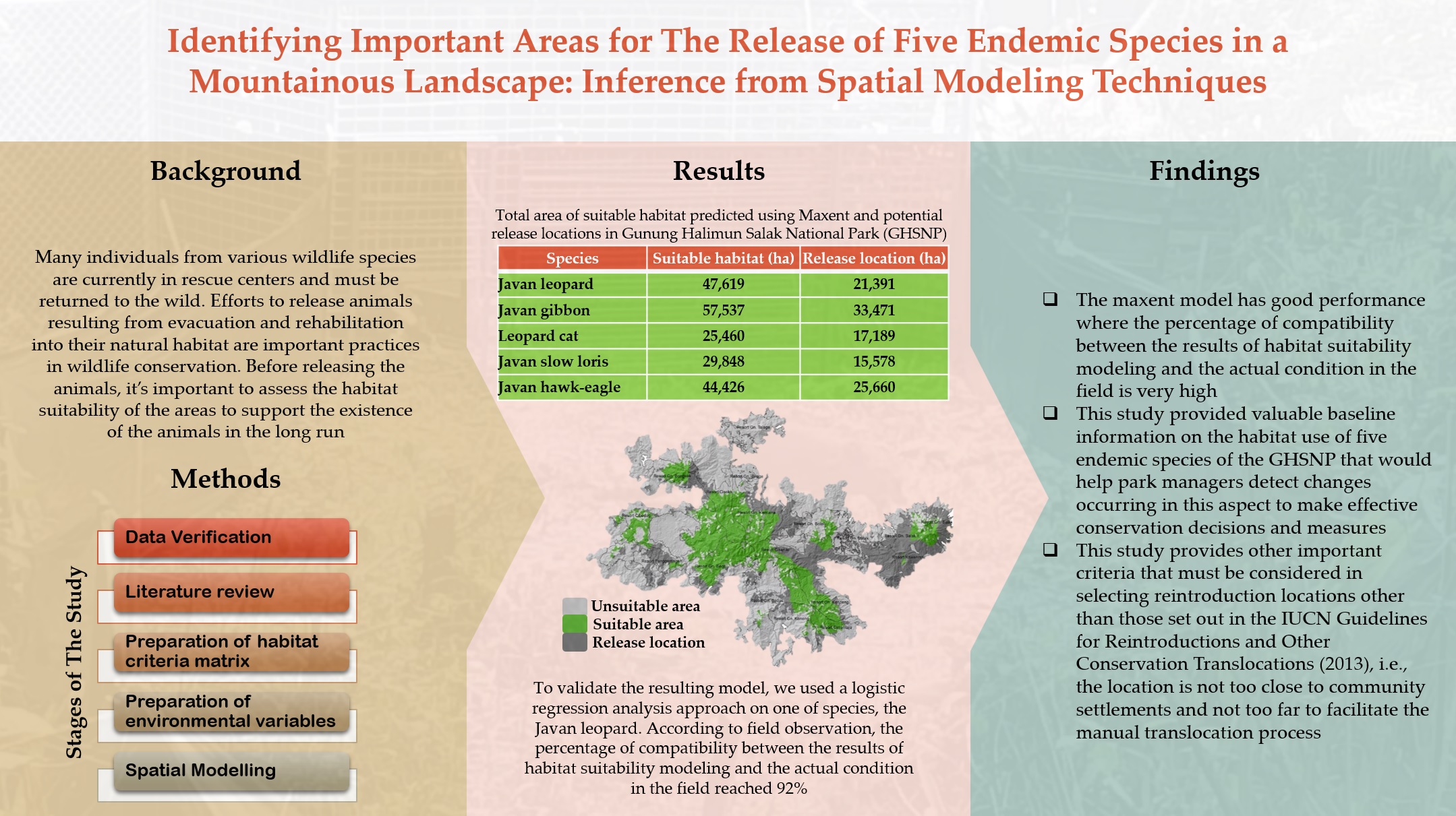
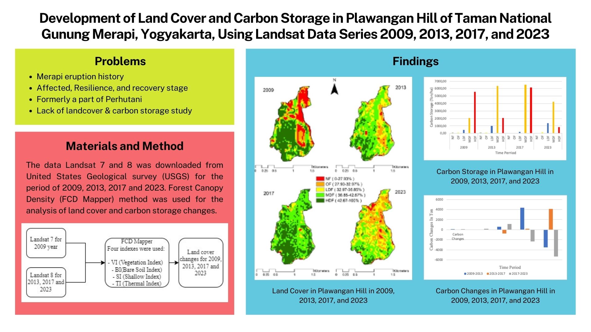
Globally, habitat loss, deforestation, and climate change are mostly caused by land cover changes (LCC). The amount of land covered by trees has had a major impact on global warming and climate change. Increasing the amount of land cover helps to mitigate climate change and global warming. This study aims to investigate the changes in land cover and carbon storage in Plawangan Hill, Indonesia, over four years (2009, 2013, 2017, and 2023). The study site was defined as a conservation area that has been periodically impacted both directly and indirectly by volcanic eruptions. Images from Landsat 7 and 8 were used to collect data. Additionally, land cover changes were assessed using the forest canopy density (FCD Mapper) model, which was then utilized to quantify the carbon storage of the research site. The findings demonstrated fluctuations in land cover changes between 2009 and 2023. Additionally, changes in land cover have a direct impact on changes in carbon storage. The age of the trees, type of vegetation, succession stage, and history of eruptions were the variables that were apparent to be the main causes of these changes.
References
Babu, R. G., Maheswari, K. U., Zarro, C., Parameshachari, B. D., & Ullo, S. L. (2020). Land-use and land-cover classification using a human group-based particle swarm optimization algorithm with an LSTM classifier on hybrid pre-processing remote-sensing images. Remote Sensing, 12(24), 4135. https://doi.org/10.3390/RS12244135
[BSN] Badan Standard Naional. (2010). Klasifikasi penutup lahan (SNI 7645:2010). BSN.
Basuki, I., Adinugroho, W. C., Utomo, N. A., Syaugi, A., Tryanto, D. H., Krisnawati, H., Cook‐patton, S. C., & Novita, N. (2022). Reforestation opportunities in Indonesia: Mitigating climate change and achieving sustainable development goals. Forests, 13(3), 447. https://doi.org/10.3390/F13030447
Bhan, M., Gingrich, S., Matej, S., Fritz, S., & Erb, K. H. (2021). Land use increases the correlation between tree cover and biomass carbon stocks in the global tropics. Land, 10(11), 1217. https://doi.org/10.3390/LAND10111217
Cohen, J. (1968). Weighted Kappa: Nominal scale agreement provision for scaled disagreement or partial credit. Psychological Bulletin, 70(4), 213–220. https://doi.org/10.1037/h0026256
Coulston, J. W., Reams, G. A., Wear, D. N., & Brewer, C. K. (2014). An analysis of forest land use, forest land cover and change at policy-relevant scales. Forestry, 87(2), 267–276. https://doi.org/10.1093/FORESTRY/CPT056
Disperati, L., Gonario, S., & Virdis, P. (2015). Assessment of land-use and land-cover changes from 1965 to 2014 in Tam Giang-Cau Hai Lagoon, Central Vietnam. Applied Geography, 58, 48–64. https://doi.org/10.1016/j.apgeog.2014.12.012
Dwi, S., & Susilowati, A. (2015). Keanekaragaman jenis dan sebaran Selaginella di Provinsi Daerah Istimewa Yogyakarta. Prosiding Seminar Nasional Masyarakat Biodiversitas Indonesia, 1(5), 987–992. https://doi.org/10.13057/psnmbi/m010505
Dwiyahreni, A. A., Fuad, H. A. H., Sunaryo, Soesilo, T. E. B., Margules, C., & Supriatna, J. (2021). Forest cover changes in Indonesia’s terrestrial national parks between 2012 and 2017. Biodiversitas Journal of Biological Diversity, 22(3), 1235–1242. https://doi.org/10.13057/BIODIV/D220320
Emaran, A., Rob, M. A., Kabir, M. H., & Islam, M. N. (2016). Modeling spatio-temporal shoreline and areal dynamics of coastal island using geospatial technique. Modeling Earth Systems and Environment, 2(1), 1–11. https://doi.org/10.1007/s40808-015-0060-z
Gertisser, R., & Keller, J. (2003). Trace element and Sr, Nd, Pb and O isotope variations in medium-K and high-K volcanic rocks from Merapi Volcano, Central Java, Indonesia: Evidence for the involvement of subducted sediments in Sunda Arc magma genesis. Journal of Petrology, 44(3), 457–489. https://doi.org/10.1093/PETROLOGY/44.3.457
Griscom, B. W., Busch, J., Cook-Patton, S. C., Ellis, P. W., Funk, J., Leavitt, S. M., Lomax, G., Turner, W. R., Chapman, M., Engelmann, J., Gurwick, N. P., Landis, E., Lawrence, D., Malhi, Y., Murray, L. S., Navarrete, D., Roe, S., Scull, S., Smith, P., Streck, C., Walker, W. S., & Worthington, T. (2020). National mitigation potential from natural climate solutions in the tropics. Philosophical Transactions of the Royal Society B: Biological Sciences, 375(1794). https://doi.org/10.1098/RSTB.2019.0126
Gunlu, A., Ercanli, I., Baskent, E. Z., & Cakır, G. (2014). Estimating aboveground biomass using Landsat TM imagery: A case study of Anatolian Crimean pine forests in Turkey. Annals of Forest Research, 57(2), 289–298. https://doi.org/10.15287/afr.2014.278
Hamilton, W. (1973). Tectonics of the Indonesian region. Bulletin of the Geological Society of Malaysia, 6, 3–10. https://doi.org/10.7186/bgsm06197301
Hillmayr, D., Ziernwald, L., Reinhold, F., Hofer, S. I., & Reiss, K. M. (2020). The potential of digital tools to enhance mathematics and science learning in secondary schools: A context-specific meta-analysis. Computers & Education, 153, 103897. https://doi.org/10.1016/J.COMPEDU.2020.103897
Hossain, K., Salauddin, M., & Tanim, I. (2016). Assessment of the dynamics of coastal island in Bangladesh using geospatial techniques: Domar Char. Journal of the Asiatic Society of Bangladesh, 42(2), 219–228.
Ishaq, R. M., Hairiah, K., Alfian, I., & van Noordwijk, M. (2020). Natural regeneration after volcanic eruptions: Resilience of the non-legume nitrogen-fixing tree Parasponia rigida. Frontiers in Forests and Global Change, 3, 562303. https://doi.org/10.3389/ffgc.2020.562303
Jakovac, C. C., Junqueira, A. B., Crouzeilles, R., Peña-Claros, M., Mesquita, R. C. G., & Bongers, F. (2021). The role of land-use history in driving successional pathways and its implications for the restoration of tropical forests. Biological Reviews, 96(4), 1114–1134. https://doi.org/10.1111/BRV.12694
Joshi, C., De Leeuw, J., Skidmore, A. K., Van Duren, I. C., & Van Oosten, H. (2005). Remotely sensed estimation of forest canopy density: A comparison of the performance of four methods. International Journal of Applied Earth Observation, 8, 84–95. https://doi.org/10.1016/j.jag.2005.08.004
Kremen, C., Niles, J. O., Dalton, M. G., Daily, G. C., Ehrlich, P. R., Fay, J. P., Grewal, D., & Guillery, R. P. (2000). Economic incentives for rain forest conservation across scales. Science, 288(5472), 1828–1832. https://doi.org/10.1126/SCIENCE.288.5472.1828/SUPPL_FILE/1047676.XHTML
Kuswantoro, F., Atmaja, M. B., Permana, W. R., & Trijoko. (2011). Diversity and feeding habit of anura in Plawangan Hill, Yogyakarta after mount Merapi eruption 2010. International Conference on Biological Science, Faculty of Biology Universitas Gadjah Mada 2011 (pp. 543–546).
Malahayati, M., & Masui, T. (2019). The impact of green house gas mitigation policy for land use and the forestry sector in Indonesia: Applying the computable general equilibrium model. Forest Policy and Economics, 109, 102003. https://doi.org/10.1016/j.forpol.2019.102003
Matheus, F. S. (2018). The role of forests and protected areas in climate change mitigation: A review and critique of the ecosystem services and REDD+ approaches. Desenvolvimento e Meio Ambiente, 46, 23–36. https://doi.org/10.5380/DMA.V46I0.54187
Melillo, J. M., Lu, X., Kicklighter, D. W., Reilly, J. M., Cai, Y., & Sokolov, A. P. (2016). Protected areas’ role in climate-change mitigation. Ambio, 45(2), 133–145. https://doi.org/10.1007/S13280-015-0693-1/FIGURES/5
[MoEF] Ministry of Environment and Forestry. (2022). The state of Indonesia’s forests 2022 towards FOLU net sink 2030. Jakarta: Ministry of Environment and Forestry.
Mon, M. S., Mizoue, N., Htun, N. Z., Kajisa, T., & Yoshida, S. (2012). Estimating forest canopy density of tropical mixed deciduous vegetation using Landsat data: A comparison of three classification approaches. International Journal of Remote Sensing, 33(4), 1042–1057. https://doi.org/10.1080/01431161.2010.549851
Moran, E. F., Brondizio, E. S., Tucker, J. M., da Silva-Forsberg, M. C., McCracken, S., & Falesi, I. (2000). Effects of soil fertility and land-use on forest succession in Amazônia. Forest Ecology and Management, 139(1–3), 93–108. https://doi.org/10.1016/S0378-1127(99)00337-0
Muslih, M. M. (2019). Analisis vegetasi penyusun hutan alam Bukit Plawangan pada tingkatan tiang dan pohon. Yogyakarta: Universitas Gadjah Mada.
Negassa, M. D., Mallie, D. T., & Gemeda, D. O. (2020). Forest cover change detection using geographic information systems and remote sensing techniques: A spatio-temporal study on Komto Protected forest priority area, East Wollega Zone, Ethiopia. Environmental Systems Research, 9, 1. https://doi.org/10.1186/S40068-020-0163-Z
Nugraha, A. S. A., & Citra, I. P. A. (2020). Modifikasi model forest canopy density (FCD) pada citra Landsat 8 multi-temporal untuk monitoring perubahan tutupan vegetasi di Kecamatan Sukasada-Bali. Jurnal Penginderaan Jauh dan Pengolahan Data Citra Digital, 17(02), 149–159. https://doi.org/10.30536/j.pjpdcd.2020.v17.a3380
Nugroho, S., Jaya, I. N. S., Saleh, M. B., & Wijanarto, A. B. (2012). Kajian metode deteksi degradasi hutan menggunakan citra satelit Landsat di hutan lahan kering Taman Nasional Halimun Salak. Jurnal Teknosains, 1(1), 26–34. https://doi.org/10.22146/teknosains.3988
Nuranisa, S., Sudiana, E., & Yani, E. (2020). Hubungan umur dengan stok karbon pohon duku (Lansium parasiticum) di Desa Kalikajar Kecamatan Kaligondang Kabupaten Purbalingga. BioEksakta: Jurnal Ilmiah Biologi Unsoed, 2(1), 146–151. https://doi.org/10.20884/1.BIOE.2020.2.1.1866
Olofsson, P., Foody, G. M., Herold, M., Stehman, S. V., Woodcock, C. E., & Wulder, M. A. (2014). Good practices for estimating area and assessing accuracy of land change. Remote Sensing of Environment, 148, 42–57. https://doi.org/10.1016/J.RSE.2014.02.015
Pawar, K. V., & Rothkar, R. V. (2015). Forest conservation & environmental awareness. Procedia Earth and Planetary Science, 11, 212–215. https://doi.org/10.1016/J.PROEPS.2015.06.027
Prach, K., Ujházy, K., Knopp, V., & Fanta, J. (2021). Two centuries of forest succession, and 30 years of vegetation changes in permanent plots in an inland sand dune area, The Netherlands. PLOS ONE, 16(4), e0250003. https://doi.org/10.1371/JOURNAL.PONE.0250003
Pratiwi, K. S. (2020). Pengembangan wisata birdwatching sebagai wisata minat khusus di Bukit Plawangan, Gunungapi Merapi. Yogyakarta: Universitas Gadjah Mada.
Priambodo, R., Arman, Z., Dewi, M., Cari, R. B., Subhi, F. N., Asharo, R. K., Pasaribu, P. O., & Rizkawati, V. (2021). Inventarisasi dan studi asosiasi anggrek epifit dengan pohon inang di kawasan Bukit Plawangan, Taman Nasional Gunung Merapi. Bioma, 17(1), 19–27. https://doi.org/10.21009/Bioma17(1).3
Pujiono, E., Sadono, R., Hartono, & Imron, M. A. (2019). A three decades assessment of forest cover changes in the mountainous tropical forest of Timor Island, Indonesia. Jurnal Manajemen Hutan Tropika, 25(1), 51–64. https://doi.org/10.7226/jtfm.25.1.51
Rikimaru, A., Roy, P. S., & Miyatake, S. (2002). Tropical forest cover density mapping. Tropical Ecology, 43(1), 39–47.
Roy, D. P., Kovalskyy, V., Zhang, H. K., Vermote, E. F., Yan, L., Kumar, S. S., & Egorov, A. (2016). Characterization of Landsat-7 to Landsat-8 reflective wavelength and normalized difference vegetation index continuity. Remote Sensing of Environment, 185, 57–70. https://doi.org/10.1016/J.RSE.2015.12.024
[RSPO] Roundtable on Sustainable Palm Oil. (2017). RSPO guidance for land use change analysis. Retrieved from https://rspo.org/wp-content/uploads/annex-3-luca-guidance-document-english.pdf
Sadono, R., Khan, K., Kusuma, A. F., Siregar, D. I., Yuwono, T., Peday, H. F. Z., & Ruhimat, I. S. (2022). Land cover and carbon storage in a certified sustainable community forest in Sumberejo Village, Wonogiri, Central Java, Using Landsat Data Series 2000, 2015 and 2020. Agriculture and Forestry, 68(3), 183–198. https://doi.org/10.17707/AGRICULTFOREST.68.3.15
Sanquetta, C. R., Corte, D. A. P., & Maas, B. G. C. (2011). The role of forests in climate change. Quebracho, 19(1–2), 84–96.
Saputra, D. D., Sari, R. R., Hairiah, K., Widianto, Suprayogo, D., & van Noordwijk, M. (2022). Recovery after volcanic ash deposition: vegetation effects on soil organic carbon, soil structure and infiltration rates. Plant and Soil, 474(1–2), 163–179. https://doi.org/10.1007/S11104-022-05322-7
Shanee, S., Fernández-Hidalgo, L., Allgas, N., Vero, V., Bello-Santa Cruz, R., Bowler, M., Erkenswick Watsa, M., García Mendoza, G., García-Olaechea, A., Hurtado, C., Vega, Z., Marsh, L., Boonratana, R., & Mendoza, A. P. (2023). Threat analysis of forest fragmentation and degradation for Peruvian primates. Diversity, 15(2), 276. https://doi.org/10.3390/D15020276/S1
Souza, C. M., Shimbo, J. Z., Rosa, M. R., Parente, L. L., Alencar, A. A., Rudorff, B. F. T., Hasenack, H., Matsumoto, M., Ferreira, L. G., Souza-Filho, P. W. M., de Oliveira, S. W., Rocha, W. F., Fonseca, A. V., Marques, C. B., Diniz, C. G., Costa, D., Monteiro, D., Rosa, E. R., Vélez-Martin, E., Weber, E. J., Lenti, F. E. B., Paternost, F. F., Pareyn, F. G. C., Siqueira, J. V., Viera, J. L., Neto, L. C. F., Saraiva, M. M., Sales, M. H., Salgado, M. P. G., Vasconcelos, R., Galano, S., Mesquita, V. V., & Azevedo, T. (2020). Reconstructing three decades of land use and land cover changes in Brazilian biomes with Landsat archive and Earth Engine. Remote Sensing, 12(17), 2735. https://doi.org/10.3390/RS12172735
Storey, J., Choate, M., Lee, K., Markham, B., Morfitt, R., Müller, R., & Thenkabail, P. S. (2014). Landsat 8 operational land imager on-orbit geometric calibration and performance. Remote Sensing, 6(11), 11127–11152. https://doi.org/10.3390/RS61111127
Sulaksono, N., & Hadiyan, Y. (2015). Conflict resolution strategy for ecosystem problems of Mount Merapi National Park: Some lesson from Jurang Jero. Seminar Nasional Masyarakat Biodiversitas Indonesia, 1(6), 1370–1374. https://doi.org/10.13057/PSNMBI/M010618
Sulaksono, N., Pudyatmoko, S., Soemardi, Wardhana, W., Hadiyan, Y., & Nurvianto, S. (2022). Response of terrestrial mammals to various types of disturbance in the Gunung Merapi National Park, Indonesia. Biodiversitas, 23(3), 1635–1647. https://doi.org/10.13057/BIODIV/D230355
Suryanto, P., Hamzah, M., Alias, M., & Mohamed, A. (2010). Post-eruption species dynamic of Gunung Merapi National Park, Java, Indonesia. Journal of Topical Biology and Conservation, 7, 49–57. https://doi.org/10.51200/jtbc.v7i.213
Sutomo, & Fardila, D. (2013). Floristic composition of groundcover vegetation after the 2010 pyroclastic fire on mount merapi. Jurnal Manajemen Hutan Tropika, 19(2), 85–93. https://doi.org/10.7226/jtfm.19.2.85
Sutomo, & Wahab, L. (2019). Changes in vegetation on Mount Agung volcano Bali Indonesia. Journal of Tropical Biodiversity and Biotechnology, 4(2), 54–61. https://doi.org/10.22146/JTBB.41008
Torres, C. M. M. E., Medina-Vega, J. A., Rocha, S. J. S. S. da, Costa, W. da S., Soares, C. P. B., Souza, A. L. de, Jacovine, L. A. G., Lana, J. M. de, & Peña-Claros, M. (2023). Drivers of tree demographic processes in forest fragments of the Brazilian Atlantic forest. Forest Ecology and Management, 534, 120893. https://doi.org/10.1016/J.FORECO.2023.120893
Tosiani, A. (2015). Kegiatan serapan dan emisi karbon. Jakarta: Kementerian Lingkungan Hidup dan Kehutanan.
Tsutsumida, N., & Comber, A. J. (2015). Measures of spatio-temporal accuracy for time series land cover data. International Journal of Applied Earth Observation and Geoinformation, 41, 46–55. https://doi.org/10.1016/j.jag.2015.04.018
Umaya, R., Hardjanto, Soekmadi, R., & Sunito, S. (2020). Livelihood adaptation patterns of sub villages community in the slope of Merapi Volcano. IOP Conference Series: Earth and Environmental Science, 528(1), 1–13. https://doi.org/10.1088/1755-1315/528/1/012020
Utami, I., Sakti, A. D., Yusuf, F. I., Husna, F., & Susanto, D. (2023). Development of secondary forest succession based on estimation of forest carbon stocks ten years post-Merapi Volcano eruption. HAYATI Journal of Biosciences, 30(5), 834–842. https://doi.org/10.4308/HJB.30.5.834-842
Velastegui-Montoya, A., Montalván-Burbano, N., Peña-Villacreses, G., de Lima, A., & Herrera-Franco, G. (2022). Land use and land cover in tropical forest: Global research. Forests, 13(10), 1709. https://doi.org/10.3390/F13101709
Voigt, M., Supriatna, J., Deere, N. J., Kastanya, A., Mitchell, S. L., Rosa, I. M. D., Santika, T., Siregar, R., Tasirin, J. S., Widyanto, A., Winarni, N. L., Zakaria, Z., Mumbunan, S., Davies, Z. G., & Struebig, M. J. (2021). Emerging threats from deforestation and forest fragmentation in the Wallacea centre of endemism. Environmental Research Letters, 16(9), 094048. https://doi.org/10.1088/1748-9326/AC15CD
Wang, S. Q., Zheng, X. Q., & Zang, X. B. (2012). Accuracy assessments of land use change simulation based on Markov-cellular automata model. Procedia Environmental Sciences, 13, 1238–1245. https://doi.org/10.1016/J.PROENV.2012.01.117
Widodo, S., Sriwidodo, Irham, & Handoyomulyo, J. (2017). Dampak erupsi Gunung Merapi terhadap kawasan Taman Nasional Gunung Merapi (TNGM) di DIY dan Jawa Tengah. SEPA: Jurnal Sosial Ekonomi Pertanian dan Agribisnis, 11(1), 130–141. https://doi.org/10.20961/sepa.v11i1.14164
Wijayati, D., & Rijanta, R. (2020). Evaluasi zonasi Taman Nasional Gunung Merapi. Jurnal Litbang Sukowati, 3(2), 92–106. https://doi.org/10.32630/SUKOWATI.V3I2.93
Young, N. E., Anderson, R. S., Chignell, S. M., Vorster, A. G., Lawrence, R., & Evangelista, P. H. (2017). A survival guide to Landsat preprocessing. Ecology, 98(4), 920–932. https://doi.org/10.1002/ecy.1730
Zhou, D., Xiao, J., Bonafoni, S., Berger, C., Deilami, K., Zhou, Y., Frolking, S., Yao, R., Qiao, Z., & Sobrino, J. A. (2019). Satellite remote sensing of surface urban heat islands: Progress, challenges, and perspectives. Remote Sensing, 11(1), 74. https://doi.org/10.3390/RS11010048
Authors

This work is licensed under a Creative Commons Attribution 4.0 International License.
Jurnal Manajemen Hutan Tropika is an open access journal which means that all contents is freely available without charge to the user or his/her institution. Users are allowed to read, download, copy, distribute, print, search, or link to the full texts of the articles in this journal without asking prior permission from the publisher or the author. This is in accordance with the Budapest Open Access Initiative (BOAI) definition of open access.Article Details